West Virginia, New River Gorge NP, Virginia, Shenandoah NP

Oct 16 - 22, 2022
Sunday Oct 16
Travel day. Direct flight from O'hare to Charleston, WV with no problems arriving at 5:15p. Our hotel was just a short drive away.
Had a nice dinner at Tidewater. Kathryn had a Seafood Medley and I had Jambalaya.
Monday Oct 17
Weather is cool (50s), overcast and windy (10-15). Not too bad for a fall hiking day.
Charleston, WV
Stopped to pick up sandwiches for lunch for our hike. Coming back to the car we noticed the car had a nearly complete flat tire. Luckily, only a mile away was a tire service center. Hung out at Starbucks while they repaired the tire. An hour later (and only $21) we were on our way.
First impressions of Charleston were all positive. People were very friendly, scenery was really nice, traffic easy and everything nice and close.
The 1 1/2 hour drive to the park gave us great views of the Appalachian Foothills in their fall colors passing through some small rural towns on our route.
New River Gorge National Park
Stopped at the Canyon Rim visitor center and talked to the rangers about hiking today and tomorrow and got our hiking plan together.
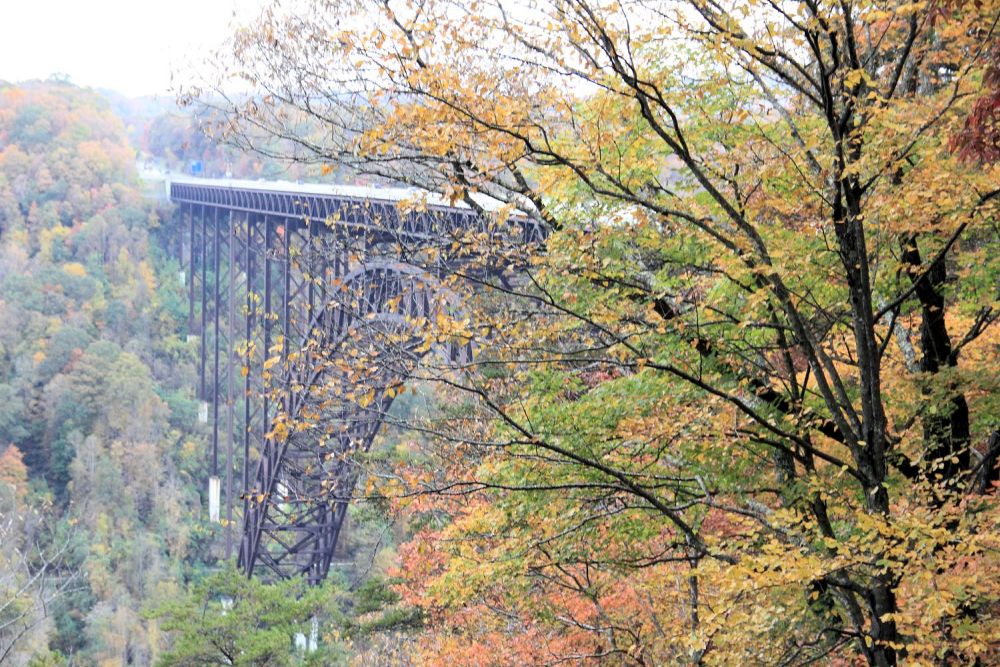
Boardwalk
A couple of pictures from the visitor center and boardwalk overlooking the bridge.
Long Point Trail
Long Point trail is in the Fayetteville section of the park near the North visitor center. It was a pretty easy hike, very little traffic and some elevation. It was the only hike today as we didn't get to the park until later in the afternoon. By the time we finished our hike the weather had turned to quite a bit cooler. We were dressed for it so it was not a problem.


Tuesday Oct 18
Weather: 31 cloudy, sleet and snow! Still, good hiking weather.
Today we planned a good day of hiking in the Grand View section of the park hiking the Grand View Rim trail and the Glade Creek trail
Grand View Rim Trail - Grandview Section
On the rim we had lots of nice views of the New River but, the Gorge was pretty socked in with mist. At the end of the trail there was a nice rock out cropping with an inviting benchThe trail was very lightly trafficked and had a fair amount of elevation gain.


Glade Creek Trail - Grandview Section
We had our typical lunch of sandwiches after our first hike just in the car since it was cold and snowy.
Our next hike was in the same section of the park but was completely different. Instead of being up on the rim, we decscended down deep into the gorge to get down to the elevation of the river to get to the trail head. The rental car was an Altima and the gravel road we drove down for several miles was steep at points. I was a little worried the car could make it back up OK but, (spoiler alert) it did just fine on the way up.
A very nice hike right along the Glade Creek and passed below one of the bridges (not the New River Bridge) far above us. We did not see anyone else on the easy flat hike except for a fly fisherman wading in the creek. This trail is a little bit off the beaten path.


Wednesday Oct 19
Weather: 33 windy and cloudy.
Shenandoah National Park
On the move again. Started the day with a 4 1/2 hour drive with the first 50 miles on winding roads through the Appalachian mountains. Luckily, the rest of the drive was on straight fast highway. We arrived at Shenandoah National Park mid afternoon, stopped by the visitor center to get our hiking plans for today and tomorrow and had a late lunch. Took the scenic drive stopping at some of the out looks on our way to our hike.
Upper Hawksbill Trail
It was a nice trail with some elevation gain to get us up to Hawksbill peak. Good hike, lightly trafficked. Up at the top there was a brick shelter that had been used by the Civilian Conservation Corps (CCC) who built Skyline Drive and all the overlooks.


Scenic Drive Overlooks
A few pictures from some of the overlooks we stopped at on Scenic Drive (thanks CCC).


Thursday Oct 20
Weather:Sunny and warmer 45-50.

For our last and biggest day of hiking (miles and elevation) we came in on the North entrance of the park and drove to the trail head (again stopping at overlooks along the way) and hiked the Compton Gap West and East Hikes.
Compton Gap West and East Hikes
This hike had quite a bit of elevation on it. You hike up to a t-intersection and going East you climb up to the peak for some nice views. Returning to the intersection you then go East hiking down to a cliff. Continuing it got steep and strenuous as you hiked around and down to the bottom of the cliff. There (you will see in some of the pictures) is a great example of the Geologic formation called columnar jointing. It's incredible to think this was made by nature typically created as lava flows cool and contract, it looks engineered. This was a good and strenuous hike. Lightly trafficked.


Lunch and Some Overlooks
After the hike we drove to a picnic area for lunch. It was a bit crowded and the few picnic tables were taken. No problem, we found a nice sunny spot under a nice tree. Nice and relaxing. Driving to the trail head for our next hike we stopped at some more overlooks to snap a few pictures.


Appalachian Trail
Our final hike in Shenandoah was a tiny section of the 2200 mile Appalachian Trail that stretches from Georgia to Maine. It was an easy hike with not much elevation (which was nice after the morning hike) and took us to the boundary of the national park. So we logged about 4 miles on the Appalachian trail and only 199g mile to go!. Hike was peaceful and very lightly trafficked.


A very good day of hiking. Time to head back to the hotel, relax and get something to eat. Just did some carry out.
Friday Oct 21
Weather: Cool and Sunny
On the move again. We had breakfast and checked out of our hotel and drove the 126 miles (2hrs, 15 min) to downtown Richmond which, as you know was the capital of the confederates during the Civil War. We stopped at the civil war museum and got tickets to the museum as well as the the president of the confederate's (Jefferson Davis) white house. The white house was a tour that started on the hour. We got directions and walked to the address the ticket counter gave us. Turned out, it was the wrong address and we found ourselves outside the State Capital. We decided to head inside and joined a tour that was in progress. But, after a bit we decided to find the White house and headed to the correct address this time. Unfortunately the walk was pretty far and by the time we got there we were way past tour time. Oh well, we walked back to the Capital area and had a really nice lunch on the patio at Chopt which serves all kinds of tasty salads. It was good.
After lunch we went to the Civil War museum. Museum was well done and we enjoyed it.
Last stop for our trip was the battlefield of the 7th day of the Seven Days War outside of Richmond on Malvern Hill. General Lee had been successfully pushing McClellan's Union out of Richmond but, the Union found good ground on the 7th day and established an array of 27 cannons covering a long slightly up hill field flanked by woods. It was one of the Union's first victories as the South was highly disadvantaged running straight into a battery of cannons. It was sobering being imagining the battle being played out. We walked the circumference of the battle field which was about 3 miles.
That is all we got to see of Richmond in a partial day. Impressions were good. The downtown was rich in history and not crowded, the museum was good and the battle field (there are a lot in the area) takes you back in time.
Virginia Women's Monument
The Virginia Women's Monument is a state memorial in Richmond, Virginia commemorating the contributions of Virginia women to the history of the Commonwealth of Virginia and the United States of America[wiki].


Government Buildings and State Capital
Lots of construction around the capital.


Civil War Museum


Malvern Battle Field

Saturday Oct 22
Weather: Cool and Sunny
Travel Day. Left for airport around 8:30a for an 11:20a flight. Unfortunately, American switched us to a 1 stop through Charlotte so a few hours longer than our original non-stop flight. Flights were uneventful. Home Sweet Home.
Summary
This was a good trip. We visited two states and two National Parks we had not been too.
Charleston, WV is pretty small, nice but not much to do. We didn't spend too much time there but, I liked the low traffic, easy to get around city and everyone we ran into was very friendly.
New River Gorge NP was great. We spent a day and a half hiking in cool autumn weather a peak fall colors.
The Airbnd we stayed in Fayetteville was really nice and close to the North entrance of the park.
Shenandoah NP was great. The scenic drive is on top of the Appalachian mountains (only about 3800' above sea level) and cuts right through the park. Very scenic indeed and all the hikes were off of this road. Hikes were great, lightly trafficked. Friday was our most strenuous hiking day of the trip.
Richmond, VA is a really nice city. It has a huge amount of civil war history and battlefields. We could have spent several more days exploring the city and the various battlefields. First impressions were very good.
All in all, a good trip!
Fun Facts
West Virginia
Charleston
Charleston is the capital and most populous city of West Virginia. Located at the confluence of the Elk and Kanawha rivers, the city had a population of 48,864 at the 2020 census and an estimated population of 48,018 in 2021. The Charleston metropolitan area as a whole had an estimated 255,020 residents in 2021. (https://en.wikipedia.org/wiki/Charleston%2C_West_Virginia)
New River Gorge National Park
A rugged, whitewater river flowing northward through deep canyons, the New River is among the oldest rivers on the continent. The park encompasses over 70,000 acres of land along the New River, is rich in cultural and natural history, and offers an abundance of scenic and recreational opportunities.
Geology: When you stand at an overlook in the New River Gorge, you notice the steep canyon walls and sandstone cliffs that characterize the area. The V-shaped canyon of the New River is an outstanding natural feature of West Virginia. It was caused by erosion that has occurred over a very long period of time, forming the cliffs and canyon walls. You can see the ongoing effects of erosion in the large rocks and slides that have tumbled from the cliffs and down into the river. (Ref: https://www.nps.gov/neri/index.htm) The gorge cuts through the Appalachian Plateau, and exposes 3200 feet of very old rocks. Most of the rocks that you can see exposed in the gorge are sandstone and shale. In the lower gorge, the New River cuts through the hard Nuttall sandstone, a unique sandstone type that is 98% quartz. The area of the lower gorge around Batoff Mountain is one of the best exposures of sandstone in the area; these rocks are among the oldest found in the gorge. (Ref:https://www.nps.gov/neri/learn/nature/geologicformations.htm)
New River Gorge Bridge
The New River Gorge Bridge is a steel arch bridge 3,030 feet (924 m) long over the New River Gorge near Fayetteville, West Virginia, in the Appalachian Mountains of the eastern United States. With an arch 1,700 feet (518 m) long, the New River Gorge Bridge was the world's longest single-span arch bridge for 26 years;[4][5] it is now the fifth longest. Part of U.S. Route 19, its construction marked the completion of Corridor L of the Appalachian Development Highway System. An average of 16,200 motor vehicles cross the bridge each day.(Ref: https://en.wikipedia.org/wiki/New_River_Gorge_Bridge)
Virginia
Virginia, officially the Commonwealth of Virginia,[a] is a state in the Mid-Atlantic and Southeastern regions of the United States, between the Atlantic Coast and the Appalachian Mountains. The geography and climate of the Commonwealth are shaped by the Blue Ridge Mountains and the Chesapeake Bay, which provide habitat for much of its flora and fauna. The capital of the Commonwealth is Richmond; Virginia Beach is the most-populous city, and Fairfax County is the most-populous political subdivision. The Commonwealth's population in 2020 was over 8.65 million, with 36% of them living in the Baltimore–Washington metropolitan area. (Ref: https://en.wikipedia.org/wiki/Virginia)
Shenandoah National Park
Just 75 miles from the bustle of Washington, D.C., Shenandoah National Park is a land bursting with cascading waterfalls, spectacular vistas, fields of wildflowers, and quiet wooded hollows. With over 200,000 acres of protected lands that are haven to deer, song birds, and black bear, there's so much to explore...(Ref: https://www.nps.gov/shen/index.htm)
Richmond
Richmond is the capital city of the Commonwealth of Virginia in the United States. It is the center of the Richmond Metropolitan Statistical Area (MSA) and the Greater Richmond Region. Richmond was incorporated in 1742 and has been an independent city since 1871. As of the 2010 census, the city's population was 204,214;[6] in 2020, the population had grown to 226,610,[6] making Richmond the fourth-most populous city in Virginia. The Richmond Metropolitan Area has a population of 1,260,029, the third-most populous metro in the state. (Ref: https://en.wikipedia.org/wiki/Richmond%2C_Virginia)